Sunday, December 14, 2014

Storm Photo of the Day 12/14/14


Stirring Beast Rising dust as a threatening wall cloud on a tornado warned supercell moves over the SW Texas countryside SW of Big Spring on  May 26, 2014.  This is about a close as a storm can get to producing a tornado without actually finishing the job.

Tuesday, December 9, 2014

Storm Photo of the Day 12/09/14


Somewhat typical front-flank wall cloud on a severe thunderstorm in NW Oklahoma near Seiling on October 4, 2014.  Although there was significant rising motion and some rotation, this storm did not produce a tornado.

Wednesday, December 3, 2014

Storm Photo of the Day 12/03/14


Web of Light: Highly electrified autumn supercell thunderstorm at dusk near Amarillo, TX on October 9, 2014.  This storm went on to produce a rain-wrapped tornado near White Deer.

Monday, November 24, 2014

Storm Photo of the Day 11/25/14


Stacked plate supercell thunderstorm SW of Waurika, OK on May 7, 2014.  One of my first chases together with Chris Sanner of the Tornado Titans. No confirmed tornadoes but it still an incredible day.

Wednesday, November 19, 2014

Storm Photo of the Day 11/19/14


Large well-developed wall cloud on a supercell near I-20 south of Strawn, TX on May 5, 2009.  Although strongly rotating, this storm did not develop a tornado.  Part of the ongoing puzzle of supercell dynamics.

Thursday, November 6, 2014

Storm Photo of the Day 11/06/14


In honor of Throwback Thursday:  Video capture of a landspout tornado in Nuckolls County, Nebraska on May 24, 2004.  The parent supercell produced 14 tornadoes and landspouts in 90 minutes.  At one time point three tornadoes on the ground and the same time.

Wednesday, November 5, 2014

Storm Photo of the Day 11/15/14


A high-based severe-warned supercell thunderstorm gusts out near Quanah, TX on April 1, 2013

Tuesday, November 4, 2014

Storm Photo of the Day 11/04/14


Rather disorganized wallcloud feature on a high-based supercell near Truscott, TX on April 1, 2013.  What makes this shot interesting is that the stream of inflow from the front flank precipitation shaft is condensed more than is often seen giving a rather surreal appearance.

Wednesday, October 29, 2014

Storm Photo of the Day 10/29/14


The classic "stair-step" structure of a developing supercell near Leedey, OK on May 19, 2010.  This rapidly developing storm produced its first tornado about 10 minutes after this shot was taken.

Tuesday, October 28, 2014

Storm Photo of the Day 10/28/14


A landspout funnel - possibly tornado - peeks out from behind the shaft of rain and hail of a relatively high-based thunderstorm near Pretty Prairie, KS on May 19, 2012.

Sunday, October 26, 2014

Storm Photo of the Day 10/26/14


Alfalfa Funnel  Storms began to develop over SC and WC Oklahoma around noon March 21, 2012 as clear skies allowed for low level heating under cold air aloft.  The storm that produced this funnel organized SSW of Alfalfa, Oklahoma and as it strengthened organized a rather well-defined mesocyclone.  Shortly after 1:30 pm about 5 miles W of Alfalfa it produced this funnel which lasted 10 minutes or so and appeared to touch down briefly.  The ground was very wet, so there wasn't much dust, but I observed weeds, grass and other debris in a ground circulation even though the tornado never fully condensed.

Thursday, October 23, 2014

Storm Photo of the Day 10/23/14


Road Warriors Storm chasers approaching a tornado as it crosses the highway N of Cherokee, OK on April 14, 2012

Wednesday, October 22, 2014

Storm Photo of the Day 10/22/14


Lawton Thunderhead  The visible power of a building supercell near Lawton, Oklahoma on March 30, 2013.  The contrast produced by the varied lighting enhances the effect of the crisp towers going up.

Friday, October 17, 2014

Photo of the Day 10/17/14


Flatland Sunset  Vibrant western Oklahoma sunset with contrails.  It was indeed a beautiful evening.  October 17, 2014

Monday, October 13, 2014

Storm Photo of the Day 10/12/14


Washita Cloudburst  High-based early evening supercell with rainfoot in central Washita County, Oklahoma near the village of Bessie on October 12, 2014 

Saturday, October 11, 2014

Storm Photo of the Day 10/11/14


Strike after Strike A tornado-warned Texas Panhandle supercell thunderstorm spits out copious lightning as it moves slowly E not from from White Deer on October 9, 2014.  Three image stack.

Friday, October 10, 2014

Storm Photo of the Day 10/09/14


Panhandle Lightning Strike Powerful cloud-to-ground lightning strike from the October 9th, 2014 tornado-warned supercell near White Deer in the Texas Panhandle.  We had visual on a brief tornado a few minutes before this shot in which the mesocyclone (and tornado according to NWS Amarillo damage survey) is completely rain-wrapped.  Notice the dust being ingested on the front edge.

Friday, May 30, 2014

Storm Photo of the Day 05/30/14


Ground-scraping wallcloud on a powerful supercell thunderstorm in SW Texas near Garden City on May 26, 2014.  Although there was plenty of rising dust with some slow rotation, no tornado developed at this point.

Thursday, May 29, 2014

Storm Photo of the Day 05/29/14


Plenty of Fuel  A second tornado-warned supercell from May 26, 2014 near Big Spring, TX.  This one was a little way S of Stanton.  Uncannily similar to the first one we chased that day.  Similar conditions, similar result.

Tuesday, May 27, 2014

Storm Photo of the Day 05/28/2014


Big Spring Beast  Menacing tornado-warned supercell thunderstorm over a farmer's field near Patricia, TX on May 26, 2014.  Although not as finely sculpted as some cells, the large, low wallcloud and layered updraft base are impressive.  The storm produced several reported brief tornadoes, none of which were easily visible.

Thursday, May 8, 2014

Storm Photo of the Day 05/07/14


Waurika Sculpture Layered left edge of a tornado-warned supercell near Waurika, OK on May 7th, 2014.  Since we were rather close to this massive thunderstorm, I really needed a wider angle lens to capture it all.

Wednesday, April 2, 2014

Throckmorton, TX Supercell April 1, 2014

Here are several shots from the Throckmorton, TX supercell yesterday evening. The cell began to develop at a dryline - frontal intersection near Stamford and moved quickly NE toward the Throckmorton area where it made a hard right turn and went tornado warned. No tornadoes witnessed, although there may have been a funnel cloud before the warning was issued. We were a bit too far from the wall-cloud to say for sure. We did encounter some quarter-sized hail later on E of Woodson with a few golf balls and tennis balls thrown in! All three photos below were shot from a position S of Throckmorton on US 183/283.

Rather high and flat sculpted barred updraft base.  6:29 pm CDT:

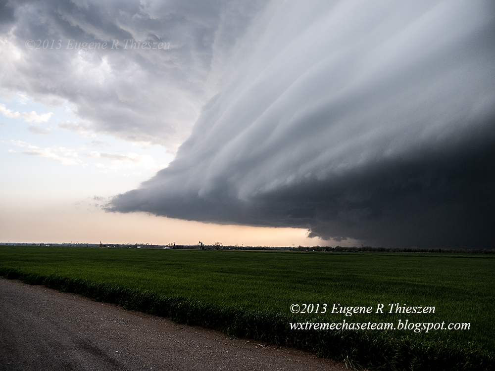
Starting to organized better as the cell went tornado-warned.  6:42 pm CDT:

Rather high-based wall cloud with rising scud.  6:48 pm CDT:


Chase Data:
Team Chase - Eugene Thieszen and Walt Gish
375 Miles
No tornadoes

Thursday, January 30, 2014

From the Archives

March 18, 2012.  West of Mangum, OK.  The second of several tornadoes on a late winter Sunday afternoon.

Wednesday, January 29, 2014

PHOTOSET: Some Favorite 2013 Supercells

April 22, 2013 Along US 283 north of Roll, OK

April 22, 2013 Along SR 47 west of Leedey, OK

April 26, 2013 Southwest of Burns Flat, OK