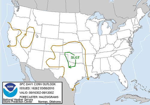
In fact rain continued for most of the morning and into the early afternoon. In its later outlook, the SPC dropped tornado possibilities altogether for Western Oklahoma. But our study of the models indicated that if some clearing could occur there was a possibility of some low-topped severe storms. By the time we left home base, there was some towering cumulus bubbling to our west near the Texas border.
We initially set up west of Elk City at the Berlin junction along along SR 6. There were some attempts at getting thunderstorms going, but nothing of note. This picture was taken looking SW at about 3:45 CST:
A storm to our west that was stronger than most motivated us to begin moving N along HWY 283, but it cycled down before long. About half-way to Cheyenne, we began to notice a strengthening storm near Berlin and elected to continue N to SR 33 which gave us a good east option to be in position as it moved NNE. Just E of Strong City, OUN issued a significant weather advisory for the storm and as we neared Hammon the base appeared to be beginning to show some organization:
But we were caught by surprise by how quickly a tornado developed. Having turned S on SR 34 we observed a tornado on the ground by the time we reached the S edge of Hammon. We pulled off the road about 3/4 S and began to film and photograph.
The time stamp on this photograph says 5:24 CST and at that point the tornado had been planted for several minutes already:
The time stamp on this photograph says 5:24 CST and at that point the tornado had been planted for several minutes already:
We continued to observe and video this tornado from that same spot for the next 20 minutes or so. A video capture of the tornado as it stirs up considerable debris. Maybe when the rural house trailer was destroyed(?)
Some more shots of the tornado as it moves NNE at about 25 mph:
When the tornado was about 1/2 mile to our W I began to get uncomfortable with our position. Here is a video capture (with rain on the lens) just before we moved another 3/4 mile S:
For a time it appear that the tornado would weaken and lift before it hit Hammon. But that was not to be. As it approached SR 34 the debris cloud darkened and we could see power flashes and objects lofted in the air.
A couple of video captures as the twister clips the S edge of Hammon doing EF-2 damage:
A couple of video captures as the twister clips the S edge of Hammon doing EF-2 damage:
Having noted by numerous sirens and flashing lights that there were plenty of emergency personnel on the scene we held position and watched the tornado rope out and dissipate ENE of town.
A couple of video captures of the final stages:
A couple of video captures of the final stages:
Another tornado developed ESE of the old meso, but our road choices and low contrast made it difficult to photograph or videotape.
This last shot is of the second tornado developing at around 6:10 CST
This last shot is of the second tornado developing at around 6:10 CST
Chase Data:
Team Chase: Eugene Thieszen and Eric Sipes
Total Miles: ~140
Team Chase: Eugene Thieszen and Eric Sipes
Total Miles: ~140
Tornadoes: 2


No comments:
Post a Comment