Sunday, April 28, 2013

More Western Oklahoma Supercells 04/26/2013

Eugene and Jason met up in Clinton, OK at around 5:15 CDT to head out toward already ongoing storms in NW Oklahoma.  Our expectations were not high, but we believed we might see some well-structured supercells.   A storm near Vici that had moved in the from the NE TX panhandle went severe shortly after we got on the road, but with development occurring S and W of that storm extending toward I-40 it was a bit difficult to decide which storm to target.

North of Clinton we elected to compromise and headed W on SR 33 toward Hammon, thus deferring our decision a bit as storms continued to develop.  At Hammon, we turned N toward Leedey on SR 34 and at that point elected to head back E on SR 47 with the severe storm near Leedey in view and the more northern storm which appeared to have a large meso-cyclone also in view.  A brief tornado was reported NW of Putnam by Tim Marshall at 6:31 CDT and though we had the wall cloud in view about 7 miles to our NNE the contrast was too low for us to see the tornado.  At this point the storm showed signs of gusting out, so we proceeded S on US 183 stopping along the way for some photographs.

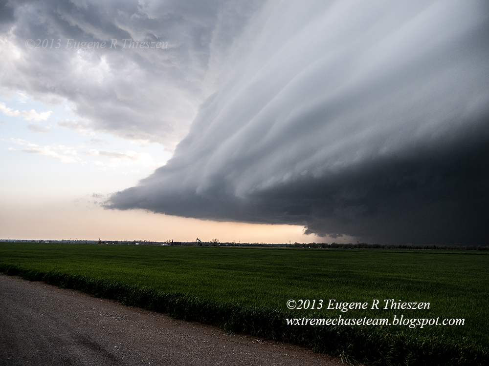
Shelf-cloud with hail behind on the northern storms at 6:49 CDT:

At this point we elected to move to intercept "tail-end charlie" which had developed W of Elk City, traveling S to Clinton then W on I-40 and then S toward Burn's Flat on SR 44.  The storm began to show some magnificent structure and we pulled off onto a church yard on the S edge of town to take some photographs.

Incredible striated bell-shaped updraft at 7:40 CDT:

This storm, as well, began to quickly gust out so we raced S to get ahead of it, eventually turning E on SR 55 at Sentinel and paralleled the supercell on its east-southeasterly track.  When we hit SR 54 at Lake Valley, darkness was falling, so we elected to call the chase rather than stay with the storm as it continued on E and SE, eventually doing some damage on the E side of Anadarko.

Chase Data:
Team Chase: Eugene Thieszen and Jason Caster
Miles: 225
Tornadoes: 0

Wednesday, April 24, 2013

Magnificent NW Oklahoma Supercell 04/22/2013

About mid-afternoon Gene and Jason left Cordell for an initial target area near Woodward OK.  Chasing prospects seemed rather marginal with a rapidly advancing cold front likely to quickly undercut any initial super cell structures along that boundary, the dry line firmly capped and rather meager moisture return. That said,  the chance of a storm near the intersection was non-zero, and if anything did develop it was likely to be photogenic.  Not far to go, so we decided it was worth the risk.

We arrived on target shortly after 5:00 pm CDT to some weak, high-based convection in the area.  Setting up along US 183/270 to wait, we observed several cells try, for the most part unsuccessfully, to get established.  When they did get established, their lives were brief - a bit of precipitation and little or no observable lightning.

Struggling convection at 5:48 CDT near Woodward in high-shear, low instability environment.

Thursday, April 18, 2013

Day of the Grungy Supercell 04/17/2013

Another southern plains moderate risk day that yielded less than expected.  Supercells yes, but since they were moving along a frontal boundary instead of developing on a dry line, they tended toward high precipitation and hence the tornadoes produced were not easily visible.  Significant cloud cover throughout the day kept instability lower than forecast and in addition there was a slight veer-back-veer in the upper wind profile, both of which contributed to storm outflow quickly undercutting inflow as tornadoes tried to establish themselves. The result: those that developed were mostly brief, lasting only a few minutes.

Walt, Eric and Gene left Cordell, OK shortly after 1:00 pm CDT initially to check out the position of the frontal boundary laying SW to NE across the body of the state and to take a look at storms developing on the cool side of that boundary.  We found the frontal boundary along US 183 between Rocky and Hobart, its position made obvious by the sudden condensation on the car windows when we crossed it.  Not long after a tornado watch was issued and we elected to continue on toward Synder or points south of there.  While on the way, an elevated supercell developed above the cooler air behind the front near Roosevelt and was quickly severe-warned. At the same time a warm-sector storm was organizing in the Vernon, TX area just S of the Red River so we continued on to Frederick and Davidson, eventually positioning on CR 2150 in Tillman County to wait on it. Jason was about 30 minutes behind the rest of the team and met the storm as it approached US 183 near Frederick.  The storm developed a rather large, very low-hanging wall-cloud as it became severe warned, but only was able manage a few transient, ragged funnel-clouds.

View of the wall-cloud from Jason's perspective on US 183 at about 3:48 CDT:

Sunday, April 14, 2013

Low Topped Cell Near Guthrie 4-14-2013

With a low risk area defined in north central OK, the marginal setup was just close enough to entice me (Jason) to head out from my home in Edmond to see what might pop up along the incoming front.  I drove to Tonkawa, OK and waited for cells to fire.

A small cluster of storms began to build and then fail just west of  Enid when one decided to root itself and build into a small LP supercell.  It never built quite enough strength to become severe, but as I let it pass to see if the storm was photogenic in sunlight, I was treated to a brilliant rainbow alongside the hail shaft.

This was the only photo of the day that turned out well, but I really like the mixture of colors it offered:


Wednesday, April 10, 2013

W Oklahoma Spring Ice Storm 04/10/2013

After several days of warm weather W Oklahoma was blasted with a surprise spring ice storm that brought down tree branches and caused numerous power outages.  The precipitation was produced by marginally severe ana-frontal thunderstorms above a layer of unusually cold air for April.  Some of the early morning storms were accompanied by quite a bit of lightning and some small hail.  Most of the ice-build up in Washita County occurred after 4:00 am CDT and anywhere from 3/8 -1/2" of ice accumulated depending on the surface.  By 6:30 am CDT the precipitation had transitioned to sleet.  Here are some photos I (Gene) shot during the early morning after the precipitation had ended.

Budding tree branch iced up:

Tuesday, April 2, 2013

Highlights Video from April 1 NW Texas Chase

NW Texas Storm Chase 04/01/2013

I (Gene) left home for a solo chase to the SE TX Panhandle/NW TX area at around 2:00 pm CDT.  My expectations were not all that high, since the tornado risk was low-end.  However, I expected some picturesque supercell action, and I was not disappointed.

While on the way to my target area near Childress,TX I noted some non-severe convection developing in the Turkey, TX area as well as a storm that exploded quickly on radar near Happy, TX, about an hour's drive to the W.  Given that the Happy storm was showing strong supercellular structure by the time I arrived on target at 3:45 CDT, I briefly considered heading toward it, but then elected to remain in the Childress area when the storm to the NW began to organize went severe.  (Obviously, I kicked myself later, since it is possible I might have made it to the Silverton area in time to see the "Caprock Magic" tornado.)

After briefly viewing the approaching storm from a position NW of Childress, I traveled through town and set up along US 287 a couple of miles ESE and waited for the storm to come to me, which took a while since it was moving at only 10-15 mph initially.

As it neared, a large, lowered area came into view through the rain.  This feature was reported by another chaser as strongly rotating. Thinking back, it was probably at this point that the storm's tornadic potential was the greatest.

View to the W from ESE of Childress along US 287 at 4:56 CDT: